Tagged in Ona Data
How ACTED Kenya-Somalia uses Ona to Ensure Better Data Quality
We are pleased to share a guest blog post written by Rose Mutisya, from ACTED Kenya-Somalia. ACTED is an international NGO operating in 35 countries around the world and is committed to providing immediate humanitarian relief to support those in urgent need and protect people’s dignity, while co-creating longer term opportunities for sustainable growth and fulfilling
New Feature: Merging Multiple Datasets Into One
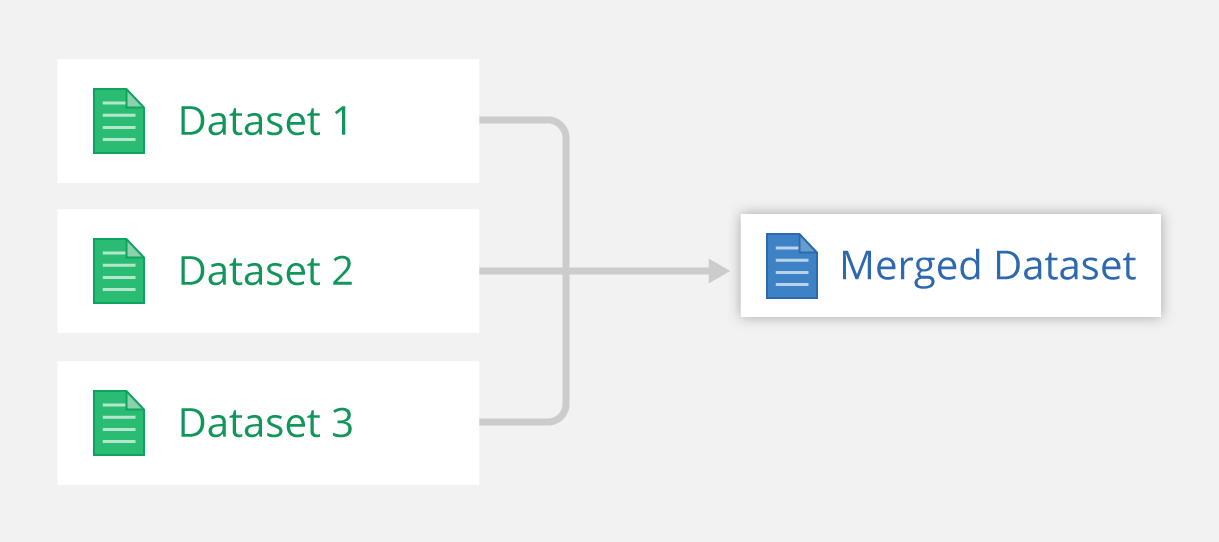
Merging datasets is a new feature that lets you combine multiple datasets from different forms into a single dataset. When datasets are merged, data from 2+ parent datasets are combined and the child merged dataset gets updated whenever changes occur in the parent datasets. Viewing data in merged datasets is similar to other datasets, allowing
Dynamically Clean Shared Data with Filtered Datasets
A filtered dataset is a subset of submitted data that satisfies certain conditions set by the user. Filtered datasets are helpful when you need to share a dataset with other users, yet want to keep certain fields or records private that are repetitive, irrelevant or sensitive. Suppose you carried out a baseline survey on households
New Help Site Launched
We are excited to announce our new help site, which makes finding answers faster with improved search functionality and article categories. The new site lets you vote on whether articles are helpful so we can improve the content. Please note, you may experience 404 errors if you use links to the old website — in that
3,725 Health Posts Mapped in Jakarta in a Massive Grassroots Empowerment Effort
Health posts in Jakarta mapped by PKK. We caught up with Renold Lim, a volunteer at Jakarta-based grassroots organization Pemberdayaan Kesejahteraan Keluarga (PKK), which aims to improve health services to the urban poor by sharing data about the realities of street-level health services. It is a colossal effort. Given that the city of 10 million
How to Increase Security by Encrypting Form Data
Encrypting form data incorporates an added level of security by making your data private, unreadable, and tamper-proof. This security mechanism can help you meet strict data privacy requirements sometimes set by ethical review boards for research studies. For example, you should encrypt data if you have surveys on highly sensitive topics like domestic violence and
Assign Granular Permissions to Forms
Restricting access to data is key in certain situations. For example, you might be collecting sensitive information and don’t want enumerators to see one another’s data. As a result, we introduced role-based permission restrictions to give you control over who among the collaborators can view and edit their data. This article will show you how
How We Helped Verify Water Points in Rural Tanzania with Ona, ODK, and OpenMapKit
Tanzania operates one of the world’s largest rural water schemes with over 80,000 public water points. To improve access to water in rural areas, DFID is supporting the Government of Tanzania through a payments-based results (PbR) scheme intended to incentivize local government authorities (LGAs) to maintain existing water points and build new ones where they
Introducing Ona Form Builder
We are thrilled to introduce Ona Form Builder today. XLSForm authoring can be challenging. In response, we have added an online form builder that lets you design Ona forms that include features like ODK question types, form logic, and validation rules. Ona Form Builder is built off an open-source form builder from Kobo. Using Ona Form
Binning and Heatmap Visualizations on Maps
To help you visualize large datasets on a map, we added binning (including 3d!) and heatmap visualizations. Displaying points works well for small datasets, but a large number of submissions can cause overlapping points, which misrepresent the data and make it difficult to see geospatial trends. Hexbins and heatmaps solve that problem through binning —